Critical Incident Maps
Precision Mapping for Swift Emergency Response
Emergency responders need instant access to vital facility information. Critical Incident Maps provide comprehensive aerial views with precise location data, helping first responders navigate your facility efficiently during emergencies.
Features and Benefits

Accurate floor plans overlaid on current aerial imagery of a building.

Site-specific labeling that matches the structure of the building.

Site-specific labeling that matches the grounds.

A gridded overlay with X/Y coordinates.

Oriented true north

Compatible with apps used by all safety officials

No additional software required.

Provided in printable and digital formats

Aids first responders in emergencies.
Product Video
One Product: Two Different Views
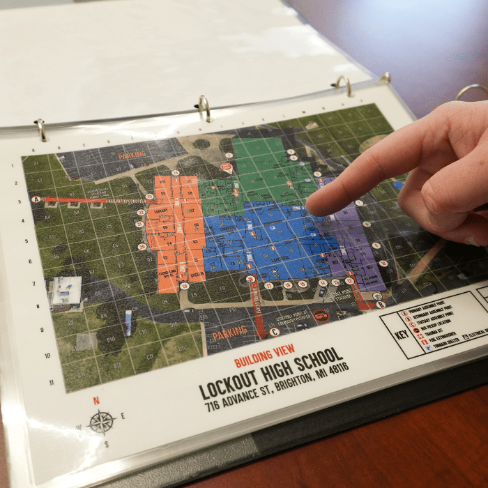
Close-Up Building View
- High-resolution aerial photography
- Grid-based reference system
- Detailed color-coded floor plan map
- Clearly labeled room names & exits
- Utility shutoff locations
- Medical equipment positions
- Main entry point identification
- Evacuation routes & meeting points
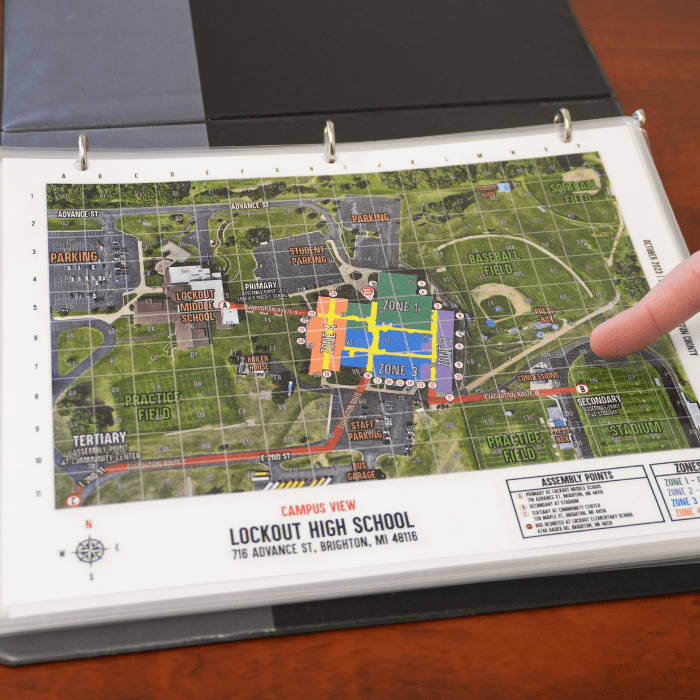
Campus-Wide View
- Full-coverage aerial imagery of building and surrounding property
- Clearly labeled building zones and entry points
- Labels for parking lots, athletic fields, and nearby buildings
- Road names
- Building evacuation routes and reunification points
- X/Y grid system overlay
How Critical Incident Maps Work
A detailed overview
Critical Incident Maps merge high-resolution aerial photography with a simple X/Y grid system and color-coded floor plan overlay.
They come as a pair: a Building View Map that captures detailed interior infrastructure information and a Campus View Map that delivers site-wide information for advanced planning and coordinated response. This combination gives a complete and detailed picture of a building and the surrounding area. Using these maps, first responders can instantly pinpoint locations in and around a building to aid with rapid emergency response.
To create our Critical Incident Maps, we start by reviewing the details of your building, including floor plans, evacuation routes, reunification points, and the locations of key utility shutoffs and medical equipment.
We take your existing emergency plans into account, provide recommendations, and help develop new ones if needed. We ensure that each area of interest around your building is labeled and verify the maps for accuracy by performing a walkthrough of the facility and grounds.
After the initial review, our mapping team flies a drone over the property to capture high-definition imagery. Using the aerial photographs as the map’s base, we layer the color-coded floor plan on top of the building, add all the labels and icons, and top it off with an overlaid X/Y grid. We provide Critical Incident Maps in print and digital formats so building administrators can easily share them with emergency managers and local first responders.

What Inspired The Critical Incident Maps
When seconds count, clear navigation saves lives. Critical Incident Maps remove the guesswork for first responders, providing instant location identification and vital facility information.
The LockOut team developed these maps in direct response to first responder feedback. Law enforcement consistently cited the need for quick access to accurate facility information during emergencies. Our maps deliver this critical data in an instant.
We recommend Critical Incident Maps as an essential component of any comprehensive emergency plan. They complement our other security solutions while providing standalone value for emergency response.
Use Cases
Suitable For Multiple Facilities
- School emergency response
- Healthcare facility navigation
- Corporate campus security
- Government building protection
- Event venue management
- Industrial facility safety
Integration With Other LockOut Products
- The SmartBoot System®
- Utility shutoff locations, evacuation routes, and reunification points are used in Emergency Operations Plans
- Grid number for room location appears on acrylic Safety Zone Diagrams
- Room and exit numbers correspond with Rapid Response Placards and acrylic facility maps
Client Testimonials
Technical Specifications
- Up-to-date aerial site imagery
- X/Y grid overlay
- Integration with existing emergency plans
- Provided in print and digital formats
- Available as an acrylic map
Ready to Enhance Your Emergency Response?
Contact our team to learn more about Critical Incident Maps and how they integrate with your existing security measures.