Guidance & Navigation Solutions

Rapid Response When Seconds Matter

Navigate with confidence. The LockOut Co.’s wayfinding system combines advanced mapping, strategic signage, and digital tools to enhance situational awareness. Designed for everyday use and emergencies, it helps occupants find safety quickly while providing first responders with vital information.

How Our Solutions Work Together

Our multi-layered approach combines physical and digital navigation tools:

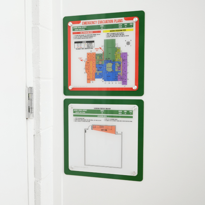
Strategic placement of maps and signage throughout facilities

Color-coded zones and Rapid Response Placards for quick identification

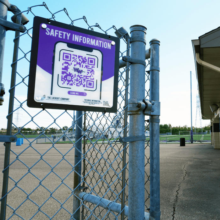
QR code-accessible venue evacuation videos

Building occupant and first responder-oriented mapping systems

Custom facility diagrams for emergency planning

Four Complete System Components

1. Acrylic Facility Maps

Our system features color-coded designs that align with building-wide safety signage for seamless navigation. Safety Zone Diagrams provide essential, room-specific information, while “You Are Here” wayfinding maps help occupants pinpoint their exact location.

Emergency evacuation maps include clear protocols and highlight critical details such as primary and secondary evacuation routes, fire extinguishers, medical equipment, storm shelter areas, and emergency exits.

2. Critical Incident Maps

Our system includes aerial building overviews with a numbered grid system for easy reference. The Building View provides a detailed floor plan map featuring room labels, color-coded zones, key utility shutoffs, building entry points, medical equipment locations, and emergency response equipment.
 
The Campus View offers a comprehensive layout of the building, grounds, and surrounding area, highlighting the interior hallway network, nearby landmarks such as parking lots, athletic fields, and street names, as well as primary and secondary evacuation routes and reunification points.

3. Strategic Signage

Our navigation system features interior and exterior placards designed for simplicity and clarity. Large exterior placards label entry points, while flat placards inside the building number exits for easy identification.

High-visibility emergency equipment markers are strategically placed and color-coded to match zoned building maps. Reflective materials and large lettering ensure optimal visibility, even in low-light conditions.

4. Event Evacuation Videos

  • Emergency plans and evacuation routes for indoor and outdoor event spaces
  • Overhead and first-person perspective for clear guidance
  • Color-coded zones and highlighted pathways to designated exits
  • Highlighted parking areas, medical resources, and severe weather shelter areas
  • Access to videos through QR code signage hung around event space
  • Display videos on facility screens before an event
Benefits
Client Testimonial

 “Parents just want their kids safe, in a positive school environment. Students want to feel safe too, and safety comes first. There’s so many fail safes that deployment happens quickly and efficiently to help keep everyone as safe as possible.”
– Vaughn White, Hesperia Community Schools

Why Choose LockOut Co. Navigation Solutions

The LockOut team brings decades of emergency response expertise to every installation. Our systems are developed and fine-tuned based on real-world crisis scenarios and first responder input. Each component works together seamlessly to protect occupants and assist with an organized and efficient emergency response.

Scroll to Top